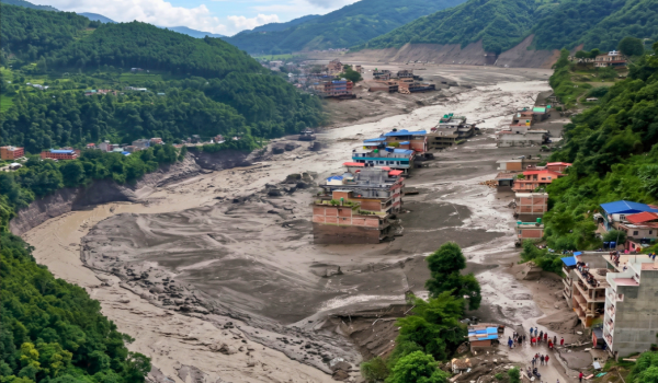


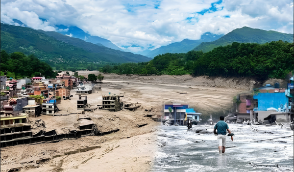
A devastating flash flood in Nepal has left a trail of destruction across several mountain communities, raising fresh questions about the forces behind the disaster. What initially appeared to be an earthquake-related event is now being linked to a far different and potentially more worrying cause: a sudden glacial collapse followed by a massive debris flow.
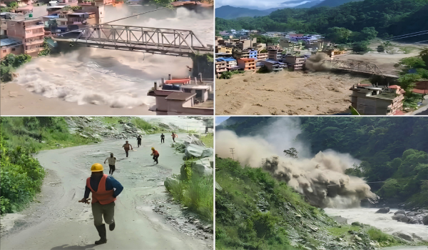
The disaster struck on Wednesday when the normally modest Bhote Koshi River suddenly transformed into a powerful torrent. Water rushed downstream carrying ice, rocks, mud, and debris, destroying homes, bridges, roads, and other structures along the riverbanks.
Videos shared on social media showed the frightening speed of the floodwaters. In some places, communities had only moments to react as the rapidly rising river swallowed everything in its path.
According to Nepal Police figures cited in the aftermath, the death toll had reached 162 by Thursday morning, while hundreds of people were still reported missing. Rescue teams continued searching affected areas as authorities assessed the scale of the destruction.
But what actually triggered the disaster? Early reports pointed towards an earthquake. A later assessment by the United States Geological Survey (USGS), however, suggested that the recorded ground movement was not caused by a conventional earthquake. Instead, it was associated with a major glacial collapse and the resulting landslide and debris flow.
A Sudden and Destructive Flash Flood
The disaster began in the mountainous region near the Nepal-China border, where an enormous volume of water suddenly entered the Bhote Koshi River system.
The surge traveled rapidly downstream, affecting areas connected to the wider Trishuli River system. The force of the water was extraordinary. Cars, bridges, and buildings were reportedly swept away, while roads were damaged or completely cut off.
The destruction also affected important transportation and trade routes in the region. Mountain communities are particularly vulnerable to this kind of disaster because settlements, roads, and infrastructure are often built along narrow river valleys.
Unlike a typical flood that develops gradually after hours or days of heavy rainfall, a glacial flood can arrive with very little warning.
That difference can make it extremely dangerous.
Was an Earthquake Responsible?
Immediately after the disaster, reports of an earthquake near the Nepal-China border attracted considerable attention.
An initial seismic reading was reportedly interpreted as a magnitude 4.4 earthquake. Because earthquakes can trigger landslides and destabilize mountain slopes, the possibility of an earthquake-induced disaster seemed plausible.
One possible chain of events was that an earthquake could have shaken loose ice, rocks, or unstable mountain material. The resulting landslide might then have blocked a river, creating a temporary natural dam. If that dam later collapsed, enormous quantities of stored water could have rushed downstream.
However, subsequent analysis changed the picture.
Rather than an earthquake causing the collapse, researchers examining the seismic signals concluded that the ground movement itself may have been generated by the glacial collapse and the associated movement of debris.
USGS Points to Glacial Collapse
The USGS later revised its initial assessment, indicating that no conventional earthquake had occurred at the location in question.
Instead, the seismic signal was linked to a large glacial collapse and debris flow.
This distinction is important.
When a massive section of ice, rock, and sediment suddenly breaks away and moves downhill, it can generate enough energy to cause ground vibrations. Seismic monitoring equipment can detect those vibrations, even though the original event did not begin deep beneath the Earth’s surface like a traditional earthquake.
Later analysis reportedly recorded the event as a magnitude 5.2 seismic signal, but the source was attributed to the collapse of glacial material and the resulting movement of debris.
In simple terms, the mountain itself may have generated the seismic signal.
How Can a Glacial Collapse Cause a Flash Flood?
To understand the disaster, imagine a huge mass of ice and rock sitting high in the mountains.
If that mass becomes unstable, it can suddenly collapse. Once it starts moving, gravity accelerates the material downhill. Ice, rocks, soil, and mud can combine into a powerful debris flow.
If this material enters a river, it can partially or completely block the river’s natural flow.
That creates a dangerous situation.
Water begins accumulating behind the blockage, effectively forming a temporary natural dam. The longer the obstruction remains in place, the more water can build up behind it.
Eventually, the pressure may become too great.
The natural dam can then break apart, releasing the trapped water in a sudden and violent surge. The floodwater does not travel alone. It can carry enormous rocks, chunks of ice, mud, trees, and other debris downstream.
That mixture makes a glacial outburst flood particularly destructive.
It behaves less like an ordinary river flood and more like a rapidly moving wall of water and debris.
River Level Rose by Around 9 Meters
One of the clearest indications of the event’s extreme nature was the rapid rise in river levels.
Researchers at the International Center for Integrated Mountain Development, based in Kathmandu, reported that the water level of the Trishuli River rose by roughly 9 meters in a very short period.
Such a rapid rise is markedly different from the pattern typically seen in a conventional rainfall-driven flood.
Heavy rain can certainly cause rivers to rise quickly, but a sudden release of water from a blocked mountain river can produce an almost instantaneous change.
That leaves communities living downstream with very little time to respond.
A Region Already Familiar With Flooding
The latest disaster has also raised concerns because the same broader area has experienced other flooding incidents in recent months.
According to comments attributed to expert Shashwat Sanyal, the Lende Khola area had experienced flooding twice during the previous 14 months.
The repeated incidents have increased attention on the stability of mountain slopes, glaciers, and river channels.
When large amounts of ice and rock enter a river, they can dramatically alter its natural flow. Temporary blockages can form, water can accumulate behind them, and the eventual collapse of those barriers can create sudden downstream flooding.
The presence of large amounts of debris also makes the resulting flood much more destructive than a normal rise in river water levels.
Could Climate Change Be Increasing the Risk?
The Nepal disaster has also renewed concerns about the impact of climate change on the Himalayan region.
Glaciers across the Himalayas are undergoing significant changes as temperatures rise. Increasing temperatures can accelerate ice melt and potentially affect the stability of frozen mountain terrain.
Scientists have warned that climate-related changes may increase the risks associated with glacial lakes, unstable slopes, ice collapses, and sudden mountain floods.
However, it is important not to oversimplify the issue.
Climate change cannot automatically be identified as the sole cause of a particular disaster without detailed scientific investigation. Mountain disasters usually result from a combination of factors, including geology, temperature, precipitation, ice conditions, slope stability, and river behavior.
Still, the latest event highlights how vulnerable high-altitude regions can become as environmental conditions change.
The Danger May Not Be Over Yet
Even after the main floodwaters pass, mountain communities can remain at risk.
Ice, rocks, and mud may continue blocking parts of a river channel. If another temporary barrier forms and later collapses, a second surge could occur with little warning.
This is why authorities have urged people living near the Bhote Koshi and Trishuli rivers to remain alert.
Rescue teams have also been working through difficult mountain terrain to locate missing people and assess damage in affected communities. Reaching isolated areas can be challenging because roads and bridges may have been destroyed by the flood itself.
A Warning From the Himalayas
Nepal’s latest flash flood disaster is a powerful reminder of how quickly conditions can change in the Himalayas.
What initially appeared to be an earthquake-related event may instead have been triggered by the sudden collapse of glacial material and a powerful debris flow. That movement appears to have contributed to a rapid release of water, ice, rock, and mud into the river system.
The scale of the destruction demonstrates why early warning systems and continuous monitoring are so important in mountain regions.
For people living downstream of glaciers and unstable mountain slopes, a disaster can develop in minutes rather than hours.
The tragedy in Nepal, therefore, goes beyond one devastating flood. It highlights the growing need to understand changing Himalayan conditions, monitor glaciers and river channels, strengthen early-warning systems, and prepare vulnerable communities for sudden natural hazards.
As scientists continue examining the event, one message is already clear: in the high Himalayas, the next major disaster may not always begin with an earthquake or heavy rain. Sometimes, the warning can come from a collapsing glacier high above the river — and by the time the water reaches the valley, there may be almost no time left to escape.