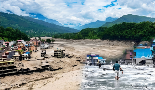


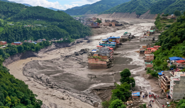
A devastating flash flood swept through Nepal’s Bhotekoshi River on Wednesday morning, leaving authorities searching for hundreds of missing people and raising fresh questions about the growing risks facing the Himalayan region.
The disaster struck in Rasuwa district before affecting neighboring Nuwakot and Dhading. According to Nepal’s Tourism Board, at least 384 tourists were initially reported missing, including 291 foreign nationals. Among them were 141 Indian citizens, including 37 non-resident Indians.
Many of the missing tourists were reportedly traveling towards the Kailash-Mansarovar pilgrimage route.
But what triggered such a powerful surge of water?
Geoscientists are now examining evidence pointing to a combination of a snow or ice avalanche, a temporary river blockage, and possibly a glacial lake outburst.
How Did the Bhotekoshi Flash Flood Begin?
According to preliminary observations by geologists, a major avalanche may have blocked the Lehenday River with huge quantities of rocks, snow, and ice.
When a river is suddenly blocked by such debris, water can begin accumulating behind the natural barrier. As the pressure increases, the blockage can eventually collapse.
That can release a massive volume of water and debris within minutes, creating a glacial- or landslide-related flash flood.
Professor Rijon Bhakta Kayastha of Kathmandu University said the sudden release of water after the river was blocked could have sent an enormous surge into the Bhotekoshi River.
According to his preliminary assessment, the avalanche may have stopped the Lehenday River, allowing water to build up until the natural barrier broke apart.
The resulting torrent then moved downstream with enormous force.
Was an Earthquake Also Involved?
The first explanation from Nepalese authorities pointed towards an earthquake.
Nepal’s Foreign Minister Shishir Khanal told Parliament that an earthquake occurred at around 8:37 a.m., followed shortly afterward by an avalanche. He said the flash flood in the Bhotekoshi began at approximately 8:40 a.m.
However, the precise relationship between the earthquake and the flood remains uncertain.
The U.S. Geological Survey reported a magnitude 4.4 earthquake at around 8:37 a.m. in Tibetan territory. Its epicenter was approximately 47 kilometers north of Gosainkunda in Rasuwa district.
Scientists are now investigating whether the earthquake triggered the avalanche or whether another geological event caused the sudden release of water.
The distinction matters because the evidence increasingly suggests that the immediate cause of the flood may have been a blockage created by ice, snow, and rock.
Could a Glacial Lake Have Burst?
Another possibility being examined is a glacial lake outburst.
Glacial lakes form when meltwater collects near or in front of retreating glaciers. These lakes can become extremely dangerous when their natural barriers weaken.
If the barrier suddenly collapses, enormous quantities of water can rush downstream, carrying rocks, mud, and ice.
Nepal experienced a similar disaster in the Bhotekoshi region in July 2025. Investigators found evidence that a glacial lake near the Nepal-China border had burst, sending a sudden surge of water into the Lehenday River.
That earlier event has become particularly important as scientists examine the latest disaster.
The possibility that similar processes may recur has raised serious concerns about whether the region is becoming increasingly vulnerable to sudden glacial- and landslide-related floods.
A Warning Was Issued Seven Years Ago
Perhaps the most alarming part of the current disaster is that scientists had already warned about increasing risks in the Himalayas.
A major study published in Science Advances in 2019 examined four decades of satellite observations across the Himalayan region, including areas of Nepal, India, Bhutan, China, and Tibet.
The research found that Himalayan glaciers had been losing ice at an accelerating rate.
Scientists concluded that glaciers were melting roughly twice as quickly after 2000 as they had between 1975 and 2000.
The study’s lead researcher, Joshua Maurer of Columbia University, said the region had lost a significant portion of its glacier ice over the previous four decades.
The findings offered a stark warning: as temperatures rise and glaciers retreat, more meltwater can accumulate in unstable locations, increasing the risk of glacial lakes and sudden floods.
Climate Change Is Making the Himalayas More Vulnerable
The Himalayan mountains are warming rapidly, and glacier retreat is changing the region’s landscape.
When glaciers lose ice, they can leave behind unstable lakes and exposed slopes. At the same time, melting snow and ice can increase the amount of water flowing through mountain valleys.
This does not mean climate change alone causes every flash flood. Geological events such as avalanches, landslides, earthquakes, and heavy rainfall can also play major roles.
But a warmer climate can alter the conditions under which these events occur.
A weakened glacier or unstable mountain slope can become the starting point for a chain reaction: ice or rock collapses, a river becomes blocked, water accumulates, the blockage fails, and a devastating flood races downstream.
That appears to be one of the scenarios scientists are investigating in the Bhotekoshi disaster.
Why the Impact Was So Severe
The Bhotekoshi River flows through a mountainous region where settlements, roads, bridges, hydropower facilities, and tourism routes are concentrated along narrow valleys.
This geography leaves communities with very little room to escape when a sudden wall of water moves downstream.
The latest flood also struck an area used by tourists and pilgrims traveling towards the Kailash-Mansarovar region.
The destruction of roads and communication infrastructure has made rescue operations even more difficult. Authorities are searching for missing tourists and residents while trying to reach areas cut off by landslides and damaged bridges.
Development in the Himalayas Adds Another Risk
Scientists have also warned that environmental damage from poorly planned development could worsen the situation.
Across the Himalayas, forests have been cleared for roads, hydropower projects, and other infrastructure. Tunnels and large construction projects are also expanding into fragile mountain terrain.
Such development does not automatically cause floods or landslides. However, construction can disturb slopes, alter drainage patterns, and increase pressure on already unstable landscapes.
The 2019 glacier study highlighted the importance of taking these environmental changes seriously, particularly as the region faces faster glacier melting.
A Disaster That Raises Bigger Questions
The Bhotekoshi flash flood is therefore more than a single natural disaster.
Scientists are trying to establish exactly what happened on Wednesday morning: whether an avalanche blocked the Lehenday River, whether a glacial lake also burst, whether the earthquake played a role in triggering it, or whether several of these factors combined to create the deadly flood.
What is already clear is that the Himalayas are becoming an increasingly challenging environment for communities, infrastructure, and travelers.
The warnings from years of scientific research show why monitoring glaciers, glacial lakes, and unstable mountain slopes is so important.
Early-warning systems could provide precious time for people living downstream to move to safer ground.
For Nepal and its neighbors, the latest Bhotekoshi disaster is a painful reminder that the risks identified by scientists years ago are no longer simply theoretical. In a rapidly changing Himalayan climate, a wall of ice, rock, and water can turn a quiet mountain river into a deadly torrent within minutes.